Professor Sung Hyo-hyun in the center of publicizing national issue on global stage
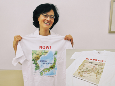
Instead of joining the general trend of setting up a booth in a corner at the conference, KCA decided to try something unprecedented; handing out T-shirts that were exclusively made to publicize the current contentious issue of the naming of the body of water between Korea and Japan. Koreans prefer the name “East Sea” whereas Japan calls it the “Sea of Japan.”
“Korea had its chance to revise the sea’s name, but unfortunately the opportunity was lost when the Korean War broke out. A lot of people tried to change the name from ‘Sea of Japan’ to ‘East Sea’ afterwards but it did not work out,” professor Sung Hyo-hyun (Social Studies) said. She participated in this conference as a member of KCA. “So this time, we thought we needed a coup de grace. SESR made a thousand T-shirts and sent them to Paris, and nobody knew about this until we unpacked the packages right there at the conference.”
Meanwhile, the National Atlas of Korea was displayed at the booth in the national atlas sector, along with another exhibition displaying an old map and a current map of Korea. Additionally, a Geographic Information System was prepared to show Korea’s progress over time. The T-shirts were handed out as souvenirs at the booth to people who participated in the conference, most of whom work in the cartography industry as cartographers or who are company employees, professors, or teachers.
However, as soon as the satellite image maps of Korea’s nautical chart and topographic map were displayed in a visible spot at the National Board sector, which is where each country is allowed to exhibit its own country’s maps, people earnestly started swarming around KCA’s booth asking for the T-shirts.
The one-thousand T-shirts were out of stock within a short time. Upon promoting the Korean map exhibition successfully, introducing a national issue on the global stage was meaningful.
In carrying out this project, professor Sung played a key role as the previous chairwoman of the KCA by applying for a spot at the ICC during her term. Chung In-chul, the current chairman, took over after professor Sung and developed specific plans for the ICC.
“Presenting Korea’s evolving technology in cartography through the exhibition and impressing the global audience was one of our aims,” Chung said. “For this year, we also had hopes for the T-shirt giveaways in helping verify the legitimacy of Korea’s claim that the contentious appellation ‘Sea of Japan’ should be replaced with ‘East Sea.’”
Professor Sung also emphasized how important it is to continue contrive ways to publicize the ongoing controversies on marking territories like the “East Sea” to the international society in a less offensive manner.
“Both countries are sensitive to the naming issue, so people should be especially careful not to negatively affect diplomatic relations,” professor Sung said. “It is practical to deliver in an indirect and agreeable way, like how our team pulled it off at this year’s ICC.”
Park Se-ra
serendipity09@ewhain.net