As the novel coronavirus, also known as COVID-19, is spreading rapidly in South Korea, university students have created websites and apps informing users of the areas previously visited by now-quarantined patients. The public is praising their work for providing easy access to essential information.
Websites such as “Corona Map” and “corona-nearby” offer people the updated trackings of the route of those infected and the number of confirmed cases. Both websites use location-based services, frequent announcements made by Korea Centers for Disease Control and Prevention, and rely on citizen reports to update information. Any user can check the number of confirmed patients, complete recoveries, and death tolls, as well as the routes and locations of those quarantined.
The main reaction of the website was overwhelmingly positive, applauding students who voluntarily took effort into developing apps and websites for the pandemic spreading in the country when normally it would be considered something the government would do in advance.
“I created the Corona Map to deliver facts to the public,” said Lee Dong-hun, also a senior in the Department of Industrial and Management Systems Engineering at Kyung Hee University, during an interview with Ewha Voice. “It is very easy to find many click-baits and fake news on the internet which only provokes unnecessary tension in society. I developed this site to better inform the public about the status quo of the coronavirus in Korea.”
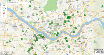
On Corona Map, depending on the color of the route, users can check how many days have passed since the patients visited a specific area. For example, a red circle means the place has been visited by the patient in less than 24 hours, whereas a green circle indicates the place has been visited within four to nine days.
Corona Map now offers an English version of the website as well as Corona_Me, another version of the website where users can simply check the previously visited area by the infected people around them. The Server of Corona Map is now funded by Naver, Kakao Corporation, and Amazon Web Service (AWS).
After its official release on Jan. 30, Corona Map started offering an English version on March 2 and is now visited by around 100 thousand people daily. According to the Ministry of the Interior and Safety, there are more than 2 million foreign passport holders living in Korea which accounts for more than 4 percent of the entire South Korean population.
“I heard many foreigners living here are only learning about the current situation of coronavirus in South Korea from their home country’s news media,” said Lee. “By launching the English version of Corona Map, I hope more people can be aware of the situation they are in by gaining information directly from a reliable local source.”
Corona-nearby was created by Choi Ju-won, Kim Jun-tae, Lee In-woo, and Park Ji-hwan, members of a computer programming education club in Korea University called “NEXT X LION.” From funding provided by Lee Doo-hee, the CEO of Like Lion, they were able to design the website from what they have learned during their one-year training in the club.
Production of corona-nearby started on Jan. 31 and was launched on Feb. 1. The distinguishing factor of corona-nearby is that it centers its service around the user. It can detect the routes patients confirmed with the virus had passed based on the users’ current location. Additionally, it offers the service of sharing locations of nearby hospitals, clinics, and public health centers.
Unfortunately, the members decided to close down the service from March 4 as they found it overwhelming to update the surging number of confirmed cases. Instead, starting on March 5, a new service dubbed “mask-nearby” was launched on the website with the help of Lee Doo-hee.
As the demand for masks increased for protection against the virus, the public has been struggling to buy them, which resulted in long lines at pharmacies. Considering the status quo and the burgeoning number of confirmed patients, the members decided a service for precaution would be more helpful than to alert them to the routes of the virus.
In addition to location-based services, mask-nearby informs them of the remaining mask stocks in convenient stores adjacent to the users. Yogiyo, a popular food delivery app, provides its pre-existing database of GPS information. Creators plan to broaden their database to pharmacy stores in the near future as the public found mask-nearby as helpful shown from the fact there were 500 thousand visitors to the website within a day of the launch.
Member Choi Ju-won expressed his gratitude to users who offered financial help as well as appreciative comments.
“We do not intend to make profits through the website,” Choi said. “The goal is to help people through our abilities.”